

The Latin America city model is a generalized urban land-use model developed by Ernest Griffin and Larry Ford. It combines concentric residential zones with a commercial spine, an elite residential sector, peripheral informal settlements, and disamenity sectors. For IB Geography, use it to explain spatial inequality, urban growth, land use, and changing city structure.
A city model looks simple because it removes detail. That is also what makes it useful. Instead of memorizing every street in a city, you learn a spatial argument: wealth, accessibility, infrastructure, and planning are distributed unevenly.
For IB students studying Option G: Urban Environments, the real goal is not merely to reproduce the diagram. It is to explain what each zone represents, connect the pattern to urban processes, and recognize where reality refuses to fit neatly inside the model.
Latin America City Model at a Glance
Before studying the details, make sure you can do five things:
- Define the model as a generalization of urban structure.
- Draw and label its principal zones from memory.
- Explain why the commercial spine and elite sector occur together.
- Connect peripheral growth to housing, migration, infrastructure, and inequality.
- Evaluate the model using evidence from a named city.
The original model was proposed by Griffin and Ford in 1980. Ford revised it in 1996 to reflect features including a market district, mall or edge city, industrial parks, a ring road, middle-class residential areas, and gentrification. This revised version is normally the most useful for contemporary analysis.
How the Model Is Structured
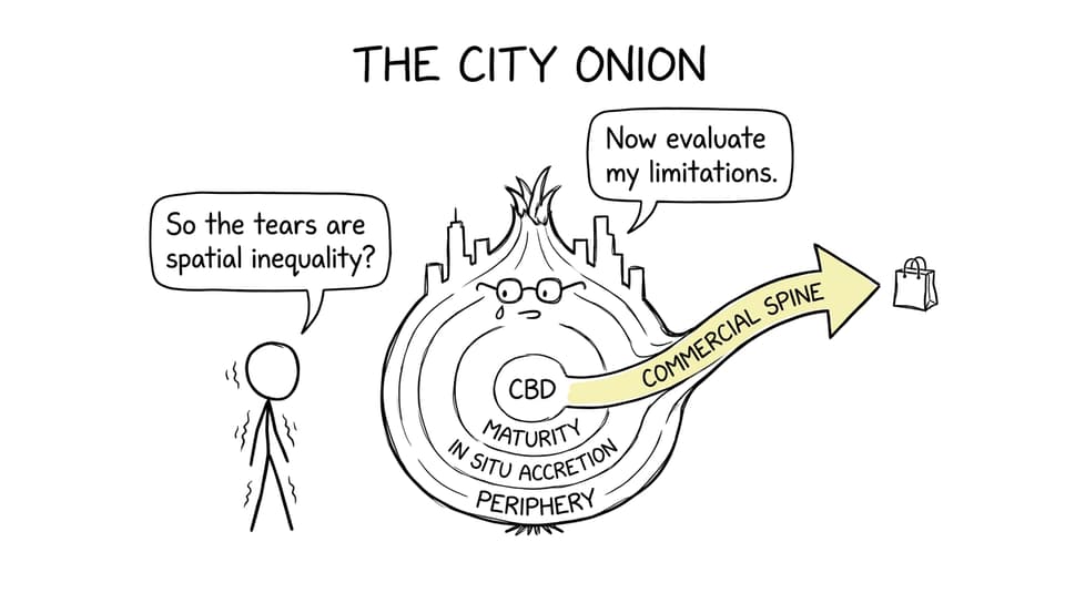
The model combines two familiar forms. Its residential zones are broadly concentric, spreading outward from the center, while the commercial spine, elite housing, industry, and disamenity areas have a more sectoral pattern.
That hybrid structure matters. It suggests that distance from the center influences urban form, but transport routes, investment, environmental quality, and social status pull development in particular directions.
CBD and market
The central business district is the commercial and administrative core. It contains offices, formal retail, services, and other activities that benefit from accessibility. In the revised model, the downtown is divided between the modern CBD and a more traditional market area.
This distinction helps students avoid treating the center as socially or economically uniform. Different types of commerce can coexist within a relatively small central area. Review the relationship between accessibility, land value, and commercial activity in RevisionDojo's urban economic activity notes.
Commercial spine and elite residential sector
A major commercial corridor extends outward from the CBD. Offices, shops, entertainment, and high-value services cluster along this accessible route. The elite residential sector develops beside it, giving wealthier households proximity to desirable services and transport connections.
At the outer end of the spine, the revised model may include a mall or edge city. This represents the decentralization of some retail and office functions without erasing the importance of the original center.
Zone of maturity
The zone of maturity surrounds much of the center. It generally contains established housing and comparatively developed services and infrastructure. Some locations may experience redevelopment or gentrification, particularly where central accessibility and historic buildings attract new investment.
Do not define maturity as wealth alone. The essential idea is consolidation: buildings, tenure, infrastructure, and services have become more established over time.
Zone of in situ accretion
Farther outward lies a transitional zone where homes and infrastructure are being improved gradually in place. Housing quality can vary considerably, while roads, water, sanitation, and electricity may be incomplete or unevenly distributed.
The phrase in situ accretion becomes easier when separated into two ideas. In situ means in the existing location; accretion means gradual addition. Residents improve buildings and neighborhoods incrementally rather than moving through a single planned development process.
Peripheral informal settlements
The outer zone represents comparatively recent and often inadequately serviced development. Housing may precede formal infrastructure, secure tenure, or comprehensive planning. Over time, however, some peripheral neighborhoods can consolidate and acquire better services.
This means the periphery should not be described as permanently static. It can become tomorrow's zone of in situ accretion or maturity as the city expands. RevisionDojo's urban growth and infrastructure notes help connect this process to wider patterns of city expansion.
Disamenity sectors, industry, and the periferico
Disamenity sectors extend through less desirable land, sometimes following transport or industrial corridors. Environmental hazards, poor accessibility, pollution, insecure land, or limited services may reduce residential desirability.
The revised model also includes industrial areas and peripheral industrial parks. A periferico, or ring road, connects outer employment, retail, and residential nodes. These additions acknowledge that economic activity no longer depends entirely on the CBD.
What the Model Actually Explains
A labelled diagram is only the beginning. The model helps you build explanations around four geographical relationships:
- Accessibility and investment: Commercial activity concentrates along well-connected corridors.
- Wealth and residential choice: Higher-income groups can compete for desirable, serviced locations beside the spine.
- Urban growth and infrastructure: Peripheral housing can develop faster than formal services are extended.
- Historical change: Consolidation, decentralization, industrial relocation, and gentrification modify earlier patterns.
These processes connect directly with the IB emphasis on the characteristics, functions, and internal structure of urban places. The characteristics of urban places notes provide a useful foundation before you attempt model-based questions.
Applying the Model to Real Cities
Griffin and Ford developed their original framework using evidence that included Bogotá and Tijuana. Yet the diagram should never be presented as an exact map of either city. A model identifies recurring relationships; it does not predict the location of every neighborhood.
When applying the model to Mexico City, Bogotá, Lima, São Paulo, or another named example, use a three-step test:
- Identify a similarity. Look for a strong center, commercial corridor, unequal service provision, peripheral expansion, or high-income sector.
- Explain the process. Connect the pattern to accessibility, land values, planning, housing supply, migration, or infrastructure investment.
- Identify a limitation. Consider topography, multiple business districts, transport changes, gated developments, redevelopment, or local planning decisions.
Prepare only evidence you can verify. RevisionDojo's guide to using geography case studies in IB exams explains how to turn place knowledge into relevant supporting evidence rather than disconnected facts.
How It Can Appear in IB Geography Questions
The official IB Geography framework includes Urban Environments as an optional theme, with attention to patterns of economic activity, residential differentiation, urban change, and planning. The named Griffin-Ford model is best treated as an analytical tool for those themes rather than as a guarantee of one particular question.
A possible practice prompt is:
Evaluate the usefulness of an urban land-use model for explaining the internal structure of a named city.
Worked response plan
Opening judgement: The model is useful for identifying broad patterns of residential inequality and corridor-based development, but its simplified and generalized form limits its ability to represent a changing city precisely.
Paragraph one: Explain the CBD, commercial spine, and adjacent elite sector. Apply this relationship to verified evidence from the named city.
Paragraph two: Explain the progression from mature neighborhoods through in situ accretion to peripheral informal development. Link this to infrastructure provision and urban growth.
Paragraph three: Examine newer elements such as ring roads, industrial parks, edge cities, middle-class tracts, or gentrification.
Counterargument: Show where the city differs because of physical geography, multiple centers, planning, transport investment, or historical development.
Conclusion: Judge which parts of the model remain most useful and which require modification.
Notice the balance. An evaluate question requires strengths, limitations, evidence, and a supported judgement. Description alone cannot complete that task. Practise changing your response to match command terms using the Urban Environments Questionbank.
Common Exam Mistakes
Treating the diagram as a universal map
Cities do not grow according to one template. Call the diagram a model, generalization, or framework, then test it against a named place.
Confusing the residential zones
Remember the outward sequence: maturity, in situ accretion, peripheral informal settlements. Housing and service consolidation generally decrease outward in the simplified model.
Forgetting the commercial spine
The spine and adjacent elite sector are defining features. A set of concentric circles alone misses the model's sectoral element.
Listing features without explaining processes
Do not stop at "elite housing is beside the spine." Explain that accessibility, services, environmental quality, investment, and purchasing power help produce the pattern.
Using an example without evaluating fit
A place name is not analysis. State which feature fits, explain why, and identify a meaningful mismatch.
Drawing an unreadable diagram
Use a large outline, clear labels, a directional commercial spine, and short annotations. RevisionDojo's Option G lessons can help you move from recognition to active reconstruction.
Quick-Reference Revision Table
| Feature | Exam-ready meaning |
|---|---|
| CBD | Formal commercial, administrative, and service core |
| Market | Traditional or less formal commercial activity near the center |
| Commercial spine | Accessible corridor of shops, offices, and amenities extending from the CBD |
| Elite sector | High-status housing beside the spine |
| Zone of maturity | Established housing with relatively consolidated infrastructure |
| In situ accretion | Transitional area improving gradually in its existing location |
| Peripheral settlements | Newer outer development with limited or uneven formal services |
| Disamenity sector | Less desirable corridor affected by hazards, industry, poor services, or insecure land |
| Periferico | Ring road connecting peripheral residential, commercial, and industrial nodes |
| Gentrification | Reinvestment and social change in selected inner-city areas |
Turn the Diagram into Exam Technique
Revise this model in layers. First, use Flashcards to recall the vocabulary. Next, redraw it from memory using RevisionDojo's Urban Environments Study Notes. Then answer a Questionbank prompt and use AI Chat or Grading tools to identify where description needs analysis.
Finally, test the knowledge under timed conditions with Predicted Papers and Mock Exams. The wider IB Geography resource hub also connects you with the Coursework Library and Tutors when you need model examples, feedback, or deeper support.
The Latin America city model becomes valuable when you stop seeing it as a picture to memorize. It is an argument about how accessibility, wealth, infrastructure, and urban change shape space. Learn the diagram, question its assumptions, and apply it carefully. That combination is what turns revision knowledge into geographical analysis.