- IB
- B.2 Interactions between oceans and the coastal places
Practice B.2 Interactions between oceans and the coastal places with authentic IB Geography exam questions for both SL and HL students. This question bank mirrors Paper 1, 2, 3 structure, covering key topics like physical geography, human geography, and geospatial analysis. Get instant solutions, detailed explanations, and build exam confidence with questions in the style of IB examiners.
The map below shows The Overview of Thermohaline Circulation.
Source: SEAICE Portal
Identify one ocean region where surface flow moves warm water toward the poles.
Identify the direction of bottom flow in the Southern Ocean (around Antarctica).
Outline one reason why deep water forms in the Labrador or Greenland Sea.
Explain two effects of thermohaline circulation on global climate patterns.
Examine how the disruption of thermohaline circulation could impact human societies.
Discuss the importance of ocean circulation in maintaining planetary energy balance.
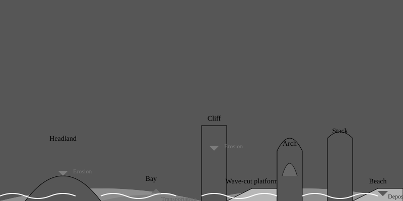
The diagram shows the formation of various coastal landforms due to physical processes such as erosion, transportation, and deposition.

- Define and describe the process of coastal erosion and its role in the formation of headlands and bays.
- Explain the formation of wave-cut platforms and cliffs as shown in the diagram.
- Describe the formation of coastal arches and stacks, including the sequential stages shown in the diagram.
- Using the diagram, analyze the role of longshore drift in the formation of beaches and spits.
- Evaluate the impact of human activities on coastal landscapes, with reference to both positive and negative effects.
The map below shows The Overview of Thermohaline Circulation.
Source: SEAICE Portal
Identify one ocean region where surface flow moves warm water toward the poles.
Identify the direction of bottom flow in the Southern Ocean (around Antarctica).
Outline one reason why deep water forms in the Labrador or Greenland Sea.
Explain two effects of thermohaline circulation on global climate patterns.
Examine how the disruption of thermohaline circulation could impact human societies.
Discuss the importance of ocean circulation in maintaining planetary energy balance.
The graph below shows the Global Fisheries and Aquaculture in Million tonnes
Source: Food and Agriculture Organisation (FAO)
Identify the period when aquaculture (marine and inland combined) surpassed capture fisheries in total production.
Identify the approximate total global fish production in 2020.
Describe the overall trend in global aquaculture production from 1950 to 2020.
Explain two environmental or socio-economic reasons for the rise of aquaculture as a source of fish production.
Examine the environmental impacts of increasing global aquaculture production.
Discuss the implications of changing global fish production trends for food security.
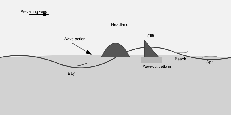
The diagram shows the coastal processes and landforms along a hypothetical coastline.

- The diagram includes features such as headlands, bays, cliffs, wave-cut platforms, and depositional features such as beaches and spits. Arrows indicate the direction of prevailing winds and wave action.
Describe the formation of headlands and bays as shown in the diagram.
Explain the process of cliff retreat and the formation of wave-cut platforms.
Discuss the factors that influence the development of depositional features such as beaches and spits.
Evaluate the effectiveness of one coastal management strategy aimed at reducing erosion along the coastline.
The graph below shows the retreat (by altitude) and the surface area of the Santa Rosa glacier in Peru.

Referring to the graph, describe the changes in the terminus of the Santa Rosa glacier from 1970–2000.
Explain the processes involved in the advance and retreat of glaciers.
Discuss the main environmental problems caused by tourism in one extreme environment.
Assess the impact of sea-level rise on coastal communities and ecosystems. Use examples in your answer.
Explain how the lithology of a coastline influences the development of coastal landforms.
Describe two physical processes that contribute to the formation of a wave-cut platform.
The map below shows the fish catch (tonnes per square kilometre) globally
Source: Based on Alhenius, H., (2008), Food and Agriculture Organisation (FAO)
Identify one region with the highest fish catch intensity
Identify one region with the lowest fish catch intensity.
Describe the global spatial pattern of fish catch intensity shown in the map.
Explain two physical or environmental factors that influence fish catch productivity in coastal waters.
Discuss the environmental consequences of overfishing in high-intensity fish catch regions.
Examine the challenges of achieving sustainable fishery management in regions of high fish catch.